 |
| Queen Anne's Landowner Map, District 3 |
Many of my ancestors lived in Queen Anne's County, Maryland. While searching for some information on the area, I came across an Ancestral Location Gallery with images of some old landowner maps, such as the one pictured above.
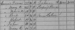
The 1870 census for Queen Anne's shows that my great-great-grandfather, Francis Councill was in the 3rd district of Queen Anne's in Centreville.
A closeup of the Spaniard Neck area where my Sparks family lived didn't show their property, but I don't know the date of this map. It's also possible that their plot wasn't large enough to show up here. I navigated up to the top of the site and found that there is a wealth of information on many different locations. The home page for the site is here and the Ancestral Location pages start here. The site isn't the easiest to navigate, but it's worth a look if you have ancestors in this area.


No comments:
Post a Comment